Let’s start by giving Google Maps its due, because most articles on this topic skip straight to the beating.
Google Maps is a genuinely extraordinary piece of engineering. The live traffic data is superb. The map coverage is close to universal. Street View has saved more drivers from a bad loading dock than any piece of trucking software ever will. And it costs nothing. If you’re driving one truck to one place, it is a perfectly good tool and you should keep using it.
The problem isn’t that Google Maps is bad. The problem is that it was built for a person driving a car to a destination, and you are running a fleet of trucks through a day. Those are different jobs. And there’s a specific, identifiable line where the free tool stops helping and quietly starts costing you money.
This article is about finding that line. Where Google Maps genuinely earns its place in a trucking operation, where it hits a wall, and what truck route optimization software actually does differently once you cross it. Five walls, in the order most fleets hit them.
What Google Maps Is Actually Good At
Be honest about this, because knowing what to keep matters as much as knowing what to replace.
Live traffic and rerouting. Few tools match it. Google sees congestion forming in near real time and reacts.
Street View for scouting. This is the one experienced dispatchers never give up. Before you send a truck to an unfamiliar address, you can drop into Street View and actually look at the entrance, the dock, the turn-in, the overhead clearance at the gate. That’s real, practical value and no route optimizer replaces it.
The final approach. Even fleets running dedicated software often hand off the last leg to a familiar navigation app. That’s fine. It’s what drivers know.
So the answer isn’t “delete Google Maps.” It’s understanding that navigation and optimization are two separate problems. Google solves the first one brilliantly and doesn’t attempt the second at all, which is the entire reason truck route optimization software exists as a category.
Wall One: The Ten-Stop Ceiling
Here’s the first hard wall, and it’s the one most fleets hit before any other.
Google Maps caps you at around ten stops per route. That’s it. If your driver has 22 drops today, you cannot put that day into Google Maps. You have to split it into three separate routes and stitch them together by hand, which means the “route” your driver follows was never planned as one route at all. It’s three fragments with seams in the middle, and the seams are where the wasted miles hide.
And here’s the part people miss. Even within those ten stops, Google Maps does not optimize. It plots the stops in the order you typed them. If you enter your manifest in the order the orders came in, that is exactly the order your driver will drive them, no matter how much backtracking it creates.
That’s the fundamental difference, and it’s worth sitting with. Google Maps answers “how do I get from here to there.” Truck route optimization software answers a much harder question: “what is the smartest possible order to visit all 22 of these places, given the traffic, the time windows, and what this truck can carry.” One is navigation. The other is optimization. A fleet needs both, and only one of them comes free.
Wall Two: It Doesn't Know Your Truck Exists
The second wall is the dangerous one.
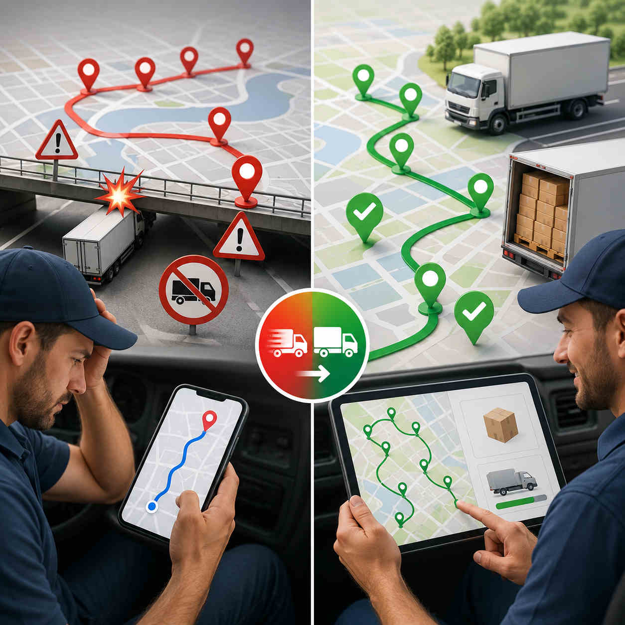
Google Maps has no truck mode. It doesn’t know your vehicle’s height, weight, length, or width, and it has no way for you to tell it. So it plans your 13-foot-6 box truck exactly the way it plans a Honda Civic, which means it will route you under low bridges, down weight-restricted roads, and onto parkways that ban commercial vehicles outright, with total confidence and no warning whatsoever.
A bridge strike is not a small mistake. It’s a five-figure repair, a wrecked load, a driver whose license is suddenly in question, and an insurance claim that follows you for years. Weight violations mean fines. And there’s no version of Google Maps where you can enter your dimensions and have it plan around them, because that capability simply is not in the product.
This is the single clearest reason fleets need a proper google maps alternative for trucking. It takes your vehicle’s real dimensions as an input and builds the route around them from the start, avoiding low clearances, weight limits, and restricted roads by design rather than flagging them after your driver is already committed to the road.
And it isn’t only bridges. Truck-safe routing also keeps rigs off roads that are legal but miserable: tight residential turns, streets with no room to reverse, entrances a trailer physically cannot swing into. Every one of those costs a driver twenty minutes and a bit of paint, and Google Maps will send him down all of them without a flicker of hesitation.
Wall Three: No Load, No Capacity, No Constraints
Even a perfectly safe, perfectly sequenced route can be useless if the truck physically cannot carry what you’ve assigned it.
Google Maps has no concept of capacity. It doesn’t know your truck holds 40 pallets, or that the load for stop 18 won’t fit alongside the load for stop 4. It doesn’t know your driver’s shift ends at four, or that the receiving dock at stop 9 closes at noon and stop 14 only accepts deliveries after 2 p.m.
Real truck route optimization software treats every one of those as a constraint the route must respect, and good fleet route optimization software does it across every vehicle at once. Vehicle capacity. Delivery time windows. Driver shift length and breaks. The route it produces isn’t just short, it’s actually executable, which is a completely different standard. A route that’s twelve miles shorter but arrives at a closed dock has cost you a redelivery, not saved you fuel.
Wall Four: Everybody Is Flying Blind
Once your trucks leave the yard with a Google Maps route, you have no idea what’s happening.
You can’t see where the trucks are. You can’t tell which driver is running ahead and which is two hours behind. When a customer calls to ask where their delivery is, you call the driver, who is driving, and either he doesn’t pick up or he pulls over to answer, and either way you now have a slower day and an annoyed customer.
There’s no proof of delivery either. When someone insists a drop never arrived, you have a driver’s memory against a customer’s invoice, and you will usually just eat the cost to keep the peace.
A multi-stop route planner for trucks closes every one of those gaps. Every truck sits on one live map. Customers get automatic ETAs and a tracking link, which deletes an entire category of phone call from your office. And drivers capture a photo, a signature, and a timestamp at each drop, so a disputed delivery ends in ten seconds instead of a week of arguing.
Wall Five: The Dispatcher's Morning
This is the cost nobody puts on a spreadsheet, and it might be the biggest.
Because Google Maps won’t optimize, and won’t take more than ten stops, the actual optimization work still has to happen. It just happens in a human brain, at 6 a.m., under time pressure. Someone opens the manifest, eyeballs the addresses, guesses a sensible order, splits the day into chunks Google will accept, divides the stops across the trucks, and sends the lists out.
That’s an hour of skilled labor, every single morning. Longer if a truck’s down or a rush order lands. And the output is a route built on intuition, which is perfectly adequate at six stops and completely hopeless at twenty-six, because the number of possible stop orders explodes past anything a person can hold in their head.
Then you add a truck and it gets worse, and not in a straight line. Now your dispatcher isn’t just sequencing stops, they’re deciding which truck gets which stops and balancing the load so one driver isn’t finished at three while another is out until seven. This is the wall growing fleets actually hit, and it’s rarely the fuel bill that forces the change. It’s the moment the morning planning session stops fitting into the morning.
Truck route optimization software collapses that hour into seconds. Import the manifest once, and every truck’s route gets planned from that single list in one pass, sequenced, capacity-aware, and truck-safe. Your dispatcher gets their morning back for the work that genuinely needs a human being.
So What Does the Free Route Really Cost?
Add the walls up and the arithmetic gets uncomfortable.
Every unnecessary mile is diesel you bought and burned for nothing. Every hour a driver spends backtracking is paid labor generating zero revenue. Every drop that didn’t fit into the day is capacity you already own and simply failed to use. Every disputed delivery you can’t prove is revenue you hand back. And every morning your dispatcher spends hand-building routes is an expensive person doing a job software finishes before they’ve finished their coffee.
For contrast, here’s what fleets running Bodha’s truck route optimization software report: fuel costs down 20 to 30%, route planning 3 times faster than by hand, and 20 or more additional stops fitted into the same day. That works out to roughly an hour less driving and over $1,000 saved monthly for a typical operation, with on-time delivery landing around 98%, for the simple reason that when a route is realistic, the ETA you promised the customer is realistic too.
Google Maps isn’t free. It just sends the invoice somewhere you’re not looking.
What Actually Makes a Good Google Maps Alternative for Trucking
If you’re shopping for a replacement, the marketing all sounds identical. Here’s what genuinely separates the real tools, and what each one means once you’re using it daily.
It plans around your actual vehicle. You enter height, width, length, and weight once, and every route from then on respects them. The test to run in a demo: hand it a route with a known low bridge on the fast path and watch whether it plans around the bridge or merely warns you about it. Those are very different products.
It optimizes, it doesn’t just sequence. Real truck route optimization software takes 25 stops and returns the order that covers them in the fewest miles, in seconds. If it simply plots the stops in the order you entered them, you’ve bought a prettier Google Maps.
It respects real-world constraints. Capacity, delivery windows, driver shifts and breaks. A route that ignores these isn’t a plan, it’s a wish.
It plans your whole fleet from one list. Import a manifest, and a proper fleet route optimization software builds every truck’s route in a single session, balanced across the fleet. The tell: if adding one more truck lengthens your dispatcher’s morning, the tool isn’t doing its job.
It shows you the day as it happens. Live tracking, automatic customer ETAs, and the ability to see which route is slipping while there’s still time to do something about it.
It proves the work. Photo, signature, timestamp on every drop, captured offline and synced when signal returns.
Miss the first two and it isn’t truck route optimization software. It’s navigation with a truck sticker on it.
Picking the Best Truck GPS App for Multiple Stops
One useful distinction before you buy, because it trips people up constantly.
A truck GPS app is built for the driver. One truck, one person, turn-by-turn guidance, truck-safe roads, maybe weigh stations and truck stops along the way. If you’re an owner-operator running a single long haul, that’s genuinely all you need.
Truck route optimization software is built for the operation. It’s what a dispatcher uses to take a full manifest and decide which truck goes where and in what order, before anyone turns a key.
So when you’re evaluating the best truck gps app for multiple stops, be clear about which problem is actually hurting you. If your drivers keep ending up on roads their trucks can’t handle, a truck-safe navigation app fixes that. If your real pain is that nobody knows the right order to visit 22 addresses, and your dispatcher is losing an hour a day guessing, no navigation app on earth will help. That’s a sequencing problem, and it needs a multi-stop route planner for trucks.
Most growing fleets eventually need both, and the good news is the better tools now do both in one place. The best truck gps app for multiple stops, in other words, is usually the one that’s also a real optimizer underneath.
Where Bodha Fits
Bodha is built for exactly the gap this article describes. It’s truck route optimization software that handles the truck-safe part and the multi-stop part together, which is precisely what Google Maps cannot do.
Enter your truck’s height, width, length, and weight, and Bodha plans around them, avoiding low bridges, weight limits, and restricted roads, while sequencing a full manifest of 20, 30, or more drops into the fewest legal miles. Routes are capacity-aware and respect delivery windows and driver shifts. Drivers get truck-safe turn-by-turn navigation with curbside arrival, and every drop is logged with proof of delivery. Live tracking puts every truck on one screen with automatic customer ETAs, so nobody has to call a driver to find out where he is.
There’s more on the Trucking Route Planner page and the route planning feature page, and if you want the deeper dive on choosing a planner, start with our guide to trucking route planners. Running a larger operation? Bodha Fleet handles multi-truck dispatch and live management.
The honest boundaries, same as we’d tell anyone: Bodha doesn’t do hazardous-material road routing, and it isn’t an IFTA fuel-tax reporting system or an ELD for hours-of-service logging. You can set driving-hour limits, shift length, and breaks as route constraints, but fleets needing true hazmat routing or IFTA filing should pair Bodha with a dedicated compliance system. What it does, keeping trucks on safe roads and manifests sequenced tight, it does well, and it’s free to start.
The Honest Verdict
Keep Google Maps. Use it for Street View, use it to eyeball a tricky dock before you send a truck, let your drivers navigate the last mile with whatever they’re comfortable with.
But stop asking it to run your fleet. It was never built for that, it doesn’t know your truck exists, it caps out at ten stops, it won’t optimize the ten it takes, and it leaves your dispatcher doing by hand the exact job that software does in seconds.
The moment your day involves more than ten stops, or a vehicle that won’t fit under every bridge, or more than one truck, you’ve crossed the line into territory that needs truck route optimization software. Everything past that line is being paid for somewhere: in fuel, in overtime, in disputed deliveries you can’t prove, and in the drops you simply never got to.
Frequently asked questions